Introduction
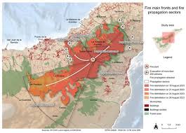
Forest fires are a significant concern for both environmental health and public safety. As climate change contributes to increased temperatures and drought conditions, the risk of wildfires intensifies. A forest fire map serves as an essential tool for tracking these threats, providing real-time updates regarding locations and extents of active fires. With the 2023 wildfire season affecting multiple provinces, understanding how to interpret this vital resource is increasingly important.
The Significance of the Forest Fire Map
The forest fire map is not just a navigational resource; it is crucial for fostering awareness among communities, policymakers, and firefighters. It displays the current status of wildfires, potential fire risks, and areas under alert due to extreme weather conditions. The information provided can help residents make informed decisions about evacuation and preparedness. Service organizations and municipal authorities rely on these maps to coordinate responses and allocate resources effectively.
Current Fire Conditions in Canada
As of late September 2023, Canada is experiencing one of its most intense wildfire seasons on record, with over 4 million hectares burned across several provinces. The most affected areas include British Columbia, Alberta, and Ontario, where ongoing dry spells and rising temperatures exacerbate fire risks. Current fire maps are updated frequently, reflecting the dynamic nature of wildfire containment efforts and environmental changes. Fires in remote areas present ongoing challenges as crews work diligently to establish control lines and monitor spread.
Technological Advances and Resources
Modern forest fire maps are often enabled by satellite imagery and advanced modeling techniques that predict fire behavior based on weather conditions, topography, and fuel availability. Websites like Agriculture and Agri-Food Canada, the provincial fire management offices, and the Canadian Wildland Fire Information System provide accessible and up-to-date data. Mobile applications are also available, offering instant alerts and customizable notifications to keep residents informed.
Conclusion
As the threat of wildfires continues to grow, the importance of forest fire maps cannot be overstated. They are critical in guiding fire management strategies and helping communities stay safe. For residents in fire-prone areas, understanding how to utilize these maps can be invaluable during peak wildfire seasons. A collaborative effort in monitoring and preparing for wildfires can lead to enhanced safety and mitigation of damages, underscoring the significance of staying informed and proactive.


