Introduction
In Manitoba, the management and prevention of wildfires have become increasingly crucial amid rising temperatures and extended dry seasons. The latest technology to aid in this endeavor is the fire map, a digital tool that provides real-time updates on active wildfires across the province. As fire risks escalate due to climate patterns, it’s essential for residents and visitors to stay informed and prepared.
What is the Fire Map?
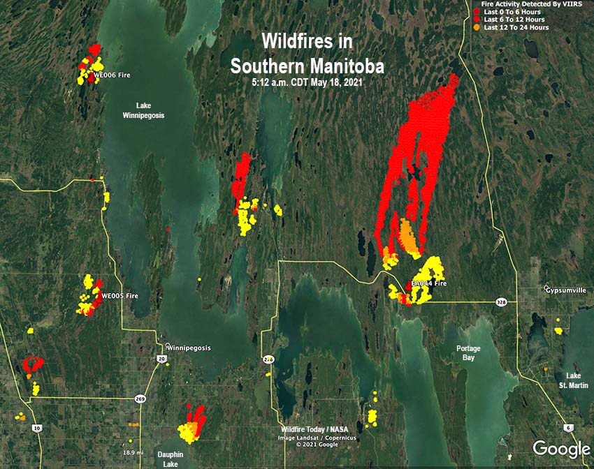
The fire map for Manitoba is an interactive online resource developed by the Manitoba Wildfire Service (MWFS). It displays locations of current wildfires, fire hazards, and prescribed burns within the province. This comprehensive map not only helps the general public access vital information but also serves as a resource for emergency responders and municipal authorities to coordinate firefighting efforts strategically.
Current Fire Situation in Manitoba
As of late summer 2023, Manitoba is experiencing an above-average fire season, with several hundred wildfires reported throughout the province since the beginning of the year. The ongoing situation has prompted the MWFS to assess fire risks regularly and to update the fire map frequently. As of September 2023, many regions, particularly in the northern parts of the province, remain under fire advisories, with recent reports indicating new active wildfires that threaten local communities and ecosystems.
Significance of the Fire Map for the Public
The fire map serves as a crucial tool for residents living near fire-prone areas. It provides essential information regarding evacuation zones, fire restrictions, and safety measures to take during wildfires. Moreover, it empowers individuals with knowledge, enabling them to make informed decisions about travel, outdoor activities, and preparedness plans. Residents can access the fire map via the Manitoba government website or through various apps that provide alerts and updates on fire conditions.
Conclusion
The fire map of Manitoba stands as an essential resource amid growing wildfire concerns. With proactive measures and the ability to monitor fire activity through technology, communities can enhance their preparedness and reduce risks associated with wildfires. As Manitoba continues to adapt to changing climate dynamics, staying informed through reliable resources like the fire map will be vital for ensuring public safety and ecological preservation. Stakeholders encourage all residents and visitors to utilize the fire map routinely in their summer planning and to remain vigilant to mitigate the impacts of wildfires.