Introduction
As wildfires become increasingly frequent and intense, understanding air quality and smoke dispersion has never been more critical. Smoke maps serve as essential tools to monitor air pollution levels and provide crucial information about health risks associated with smoke exposure. These maps help residents, especially in affected areas, make informed decisions for their safety.
What Are Smoke Maps?
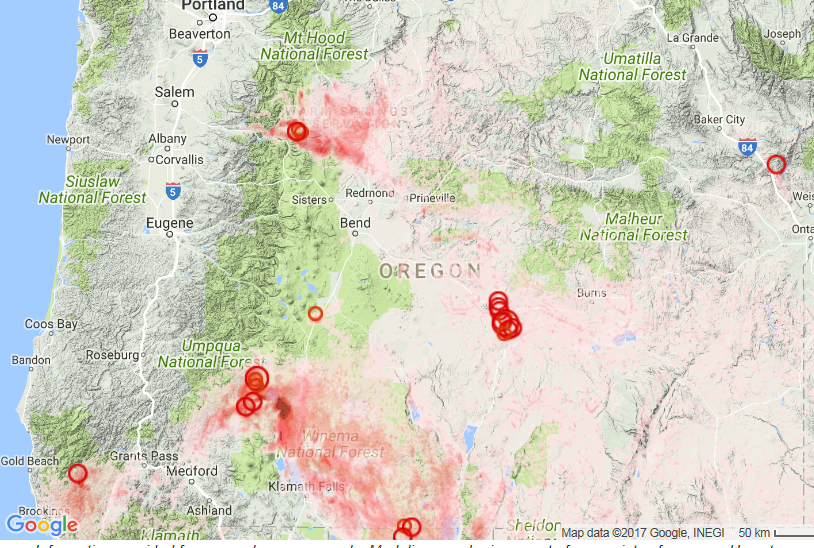
Smoke maps visually represent areas impacted by smoke, usually produced by wildfires. They utilize satellite data, ground-based observations, and atmospheric models to depict smoke movement and density in real-time. Governmental agencies, like Environment Canada and the National Wildfire Coordinating Group, regularly produce updated smoke maps during wildfire events.
Recent Events and Developments
In Canada, the summer of 2023 saw unprecedented wildfire activity, particularly in British Columbia, Alberta, and parts of the Northwest Territories. According to the Canadian Interagency Forest Fire Centre, approximately 7.2 million hectares of land were scorched as of mid-September 2023, leading to significant air quality concerns. Smoke maps were widely disseminated to the public via social media and local news outlets, providing updates on smoke trajectories and health advisories.
The Health Canada Index also correlated smoke map data with health warning levels, advising vulnerable groups such as the elderly, children, and those with respiratory issues to limit exposure. Furthermore, cities like Vancouver implemented emergency air quality measures based on the data provided by these smoke maps, including the opening of cooling centers equipped with air filtration systems to aid those suffering from smoke inhalation.
Impact and Significance
The application of smoke maps goes beyond immediate public safety; they also play a pivotal role in environmental science and policy. Researchers have been using these maps to study patterns in air quality degradation over time, informing climate change policies and resource management decisions. As technology advances, the accuracy of these maps is expected to improve, allowing for better predictive capabilities regarding air quality issues.
Conclusion
As wildfires continue to be a pressing concern worldwide, the relevance and utility of smoke maps will only grow. These tools will be crucial not only for real-time monitoring during wildfire events but also for long-term health and environmental strategies. Individuals should remain informed about the air quality in their regions through these maps, as they play a significant role in safeguarding public health and safety.