Introduction
As wildfires become increasingly common due to climate change and urban expansion, understanding fire maps has become crucial for communities across Canada. Fire maps provide vital information about fire hazards, areas at risk, and serve as an essential tool for emergency planning and response. Given the growing threat of wildfires, having access to accurate and up-to-date fire maps can mean the difference between safety and disaster for many residents.
What is a Fire Map?
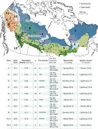
Fire maps are graphical representations that display the risk of wildfires in various regions. They illustrate areas that are more likely to catch fire based on factors such as vegetation types, weather patterns, and historical fire data. These maps are created using advanced technologies like Geographic Information Systems (GIS) and satellite imagery, allowing for real-time data to be incorporated.
Current Events and Applications
In recent months, regions in British Columbia and Alberta have seen an increase in wildfire activity. The government has utilized fire maps to implement precautionary measures, including evacuations and road closures. For instance, during the summer of 2023, nearly 200 wildfires were reported in BC alone, prompting officials to release detailed fire maps to assist locals in understanding their proximity to active fire zones and to plan safe escape routes.
The increased use of fire maps has also been echoed in public safety campaigns, where local governments are encouraging residents to familiarize themselves with these resources, especially in high-risk areas. Citizens can now access fire maps through various platforms, including government websites and mobile applications, making it easier for individuals to stay informed.
How to Use Fire Maps
Understanding and utilizing fire maps is straightforward. Residents should first identify their location within the provided maps, then assess the risk ratings and any current alerts. Maps usually include layers indicating fire danger levels, evacuation routes, and shelter locations, making them instrumental in emergency situations.
Conclusion
As wildfires continue to pose a significant threat, communities must rely on fire maps for preparedness and safety. These tools not only help in identifying risks but also enhance awareness and response strategies for residents. With increasing access to technology and information, the ability to interpret fire maps is becoming an essential skill for community members. As we move forward, investing in fire mapping technologies and educating the public will be key to minimizing the impact of wildfires and ensuring community resilience.


